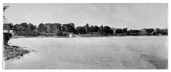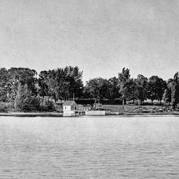
A couple of weeks ago I received an email from friend and Essex neighbor, Todd Goff with a download link to that spectacular photograph above portraying an early 1900s panorama of the Essex waterfront. Actually, the image above has been shrunk down from a 9″ wide original and web optimized to accelerate load time (and avoid breaking the internet!) The photo requires squinting to blaze through the blur, but I’ll include a couple of blown up details below to help you zoom in. I’m working with Photoshop to optimize a higher definition version of this unique northward glance from Begg’s Point across was once known as Blood’s Bay. In addition to the rare capture of Rosslyn’s dock house / boathouse and Crystal Spring Farm (aka Hayward House) — BOTH visible with virtually everything else obscured by trees — the close up offers a remarkably clear view of the dock house gangway and outer pier access.
Blood’s Bay Waterfront
Todd consistently unearths remarkable vintage and historic images of Essex. Any time a message arrives from him my heart skips a beat in anticipation of what new find he might be passing along. This unique Essex waterfront view that he sent to me and to Willie Wilcox, owner-restorer of Crystal Spring Farm, raised the bar considerably!
Here’s the gist from Todd’s January 23 and 28 messages.
I came across this 3×9” print today. Shows what was on the Rosslyn Redux image from a different angle and the Hayward House. It is actually a 400mb file with great details… It was in a box of things from Mom related to Essex. No details other than it appears like silver and black on the print vs black and white. Must be some kind of printing technique. I noticed the “arch bridge” railing frame to your dock was similar to one image you posted recently. I had not seen that detail before. Both show some monolithic black block near sandy point or Cross’. I have no idea what that was. It was neat to see the view of Willy’s/Hayward’s too. — Todd Goff
Thank. You. Todd. This is on your best finds yet!
Rosslyn Dock House
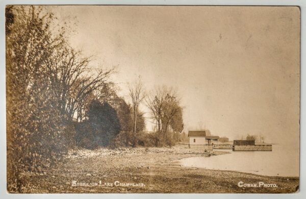
Here’s the image of the dock house with an “arch bridge” railing frame that Todd’s referring to. (Note that this building has been referred to as both a dock house and a boathouse, but the current images appear to emphasize its construction atop a pier projecting out into the lake, so for the sake of clarity I will use the term “dock house” exclusively in this post.)

The section between the two piers (the western pier with dock house and the eastern pier with coal bin) are conjoined by what does indeed resemble a bridge or suspended gangway. Although it’s worth noting that the truss construction actually differs slightly in the two historic photographs. In the sepia image I published on January 19, 2023 in my “Historic Rehabilitation” post the not insignificant span between the two piers is supported with symmetrical bracing akin to inverted truss-like brackets or corbels. In Todd’s photograph the span appears to be supported with a more conventional “bowstring” truss, supplemented with a pair of vertical pilings underneath the bridge / gangway.
The closeup below better illustrates what I’m describing.

In Todd’s photo it also appear that the gangway from shore to the dock house is suspended rather than the solid structure we inherited. Each new twist and turn makes me wonder, makes me dig deeper into our mushrooming collection of historic images. Slowly building a “time machine”…
And ruminating on the pros and cons of how best to support the span in the outer gangway (especially given the challenges posed by winter ice and spring ice flows when the water lever is far higher), I found myself looking back at Old Stump bridge to see what sort of structural accommodations were used in that construction. And, as I drift from the suspended bridge in front of the dock house, I also note that Rosslyn’s bathhouse is very much visible just north of the dock house. Do you remember that?
Crystal Spring Farm
I share Todd’s intrigue with the open southerly view from Hayward House (aka Crystal Spring Farm) since that view is dramatically different today. In addition to the built environment changing, reforestation throughout this area of Essex has dramatically altered many of the historic images from the late 1800s and early 1900s. Here is a close up detail of Crystal Spring Farm.

It’s notable what a handsome facade the property’s southern elevation affords, now concealed from the public viewshed. The perfectly cropped view of St. Joseph’s Church (see feature on Essex community blog) also stands in stark contrast to our contemporary waterfront, as does the notable block at right in this blowup. It appears to be a large bunker of some sort. I share Todd’s curiosity. Perhaps sharing this image will enable us to crowdsource this mystery?

What do you think?